date_range
Wednesday 07 Oct 2026


 LOCAL EDITION
close
 LOCAL EDITION


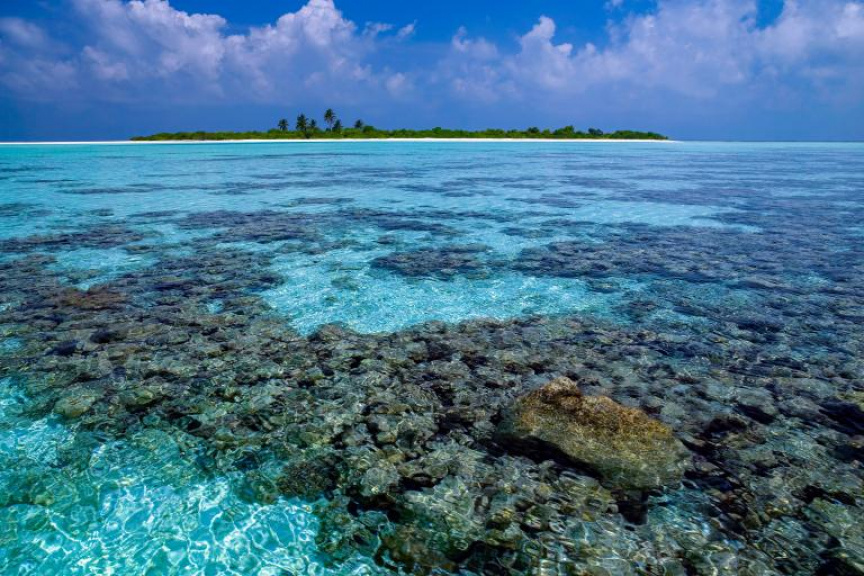
Coral reef in the Maldives. (Photo/SteveAllenPhoto999)
The Maldives’ efforts to map its fragile ecosystem has been extended to turn climate coordination into real-world impact, with the country selected as the pilot site for the iClimateAction’s Work Package 3 (WP3) demonstrator.
The iClimateAction initiative is funded by the European Commission and co-managed by the World Meteorological Organization (WMO), the Global Climate Observing System (GCOS), and the Group on Earth Observations (GEO).
Since 2024, the Maldives has been working with GEO’s Global Ecosystems Atlas initiative, with support from the United Kingdom’s Department for Environment, Food and Rural Affairs (Defra), to develop the country’s first national ecosystem map through the In-Country National Mapping Accelerator program.
In the Maldives, the National Accelerator is implemented as a collaboration between GEO and the Environment Ministry, building on earlier ecosystem mapping work undertaken by the IUCN in 2019.
The WMO states that is why the Maldives was selected as the pilot site for WP3’s ecosystem demonstrator: it offers an existing, nationally led ecosystem mapping effort that can now be extended to test how climate information can better support ecosystem-based decision-making.
Through a formal agreement between GEO and the United Nations University – Institute for Environment and Human Security (UNU-EHS), the demonstrator brings together scientific expertise, global data systems, and national stakeholders to address a practical question: how climate variables can be linked with ecosystem information in a way that directly supports adaptation planning and resilience.
Climate data is typically organized around ECVs - such as temperature, precipitation, or sea level - defined and standardized by GCOS.
Ecosystems, however, are understood in terms of Ecosystem Functional Groups (EFGs), such as subtidal rocky reefs, intertidal forests and shrublands, or tropical lowland rainforests, as defined by the IUCN.
Until recently, these two frameworks have largely operated in parallel.
The WP3 Maldives demonstrator is working to bring them together.
The WMO states that by linking ECVs with EFGs, UNU-EHS is developing a framework to understand and assess ecosystem’s vulnerability to climate change that allows decision-makers to understand where nature-based solutions can strengthen resilience.
The demonstrator represents a real shift from observing the climate to understanding its impacts and acting on them.

Vast amount of in-country work was conducted over 2024 and 2025, as part of the Global Ecosystems Atlas National Accelerator. WMO states that one of these engagements, the field mission conducted in September 2025, marked a critical step in the work of mapping the Maldives EFGs: moving from modelled data to validated, country specific information.
Over a period of four weeks, joint teams composed of Maldivian experts and international researchers visited dozens of islands and coastal sites.
At each location, the teams identified dominant ecosystem types across defined spatial scales, recorded vegetation structure, soil and water conditions, assessed ecosystem transitions and signs of disturbance, and compared observed conditions with satellite-based classifications
This process allowed for a direct validation of the data and highlighted areas where classifications required adjustment.
The WMO states that the mapping outputs are now in their final iteration phase, with technical review and validation continuing between James Cook University (JCU), Allen Institute for AI (Ai2), and the Maldives Environment Ministry.
Through WP3, the validated map output will be directly linked to ECVs, ensuring consistency with global observation standards defined by GCOS.
The Maldives demonstrator will illustrate potential new avenues that could be opened through collaboration between GCOS, GEO and WMO.
First, data becomes interoperable. Climate variables defined at the global level can be directly linked to ecosystem indicators at the national level.
Second, information becomes usable. Instead of isolated datasets, decision-makers gain integrated insights into ecosystem health and vulnerability.
Third, services become relevant. Climate information is translated into tools that support concrete actions, from ecosystem management to adaptation planning.
Finally, models become transferable.
The methodology developed in the Maldives is designed to be adapted to other Small Island Developing States facing similar challenges.
The Maldives is composed of 1,192 islands. Over 75 percent of the country’s landmass sits barely one meter above sea level, making it the lowest-lying country in the world and exceptionally vulnerable to rising sea levels and climate change.